Paddlesport Safety: Raising the Alarm Inland on Rivers, Lochs and Canals
Important advice for safety on the water written by Calum McNicol and first published in the Scottish Paddler magazine.
We all hope we will never have to use it, but having the knowledge, the skills and the hardware to summon help when things go wrong in remote locations is essential. Knowing who to call, what to say and what pieces of kit to use may well help reduce the time that outside assistance takes to turn up on scene. For now we are dealing with inland incidents, be it on the river, the loch or the canal.
When things go wrong and we are needing professional assistance, we should be initialling a distress call by dialling 999. This is often the quickest way of raising an alarm but have you given any thought into what to say during the initial call? The words we use to describe an incident and the way in which we explain our location go a long way to determine who, how and when outside assistance will come to assist.
Decision Making
Before we talk about the mechanics of raising an alarm, let's take a step back and briefly think about the reasons for training: for building knowledge, for practice and for reflection. It's all connected, so please stick with me. Broadly speaking, brain space is taken up when thinking about solutions to the problems we face in unfamiliar situations. Yet with time, experience, skills and knowledge help in our ability to process quick decisions. There's a theory that broadly speaking we have two ways of processing thoughts; which are Type 1: Fast (Intuitive, Natirisitic, Non-deliberative) and Type 2: Slow (Analytical, Rational, Systematic). The time we have to form a solution and the amount of information we can recognise and understand determines which type of thinking we use.
In an emergency situation, which the majority of us have probably not experienced that often, there will be a multitude of competing factors running through our heads, including our own safety, the safety of the group, the casualties, first aid requirements, egress and access points, mobile coverage, who to call - these are all problems we have to process.
If we want to stand a chance of dealing with an incident in an efficient and effective manner then we should be pre-loading our thoughts with plans way before an incident unfolds plus we must be on the button with our understanding of what's going on around us. The previous article, expertly written by Pete White, explains the need for good Situational Awareness in the paddlesports environment.
Passage/Journey Planning
You’ll be mistaken for thinking that the passage plan is a thing of the sea. Why do we spend so much time studying charts, working out distances, routes, harbours, places of refuge? One answer could be that we are preloading our thoughts, in slow time, with little risk and with a multitude of solutions. By looking at charts and maps we are familiarising ourselves with pictures, not written words. We are being rational with our planning. We are using slow time thinking which will help in the future when we have to call on speedy solutions in the field.
Hand on heart, how often do we do this on inland journeys on rivers, canals or lochs? Do we regularly look beyond where we are getting on and getting off and description of rapids or trips? Do we become so focused on the difficulty or challenge, that we miss opportunities to think further afield? In the future, it may be that we spend some time looking beyond the water itself and study the contours of an OS map to determine whether the banks are steep and accessible. It could be that we look at whether there's dense forest instead of open ground; we could look for and identify roads, track and paths downstream close to the water, where the emergency services can access if required. Does the right bank give more options than the left to evacuate?
I challenge you to conduct a meaningful journey plan for your next trip and ask yourself some of the pertinent questions above.
Who Are We Going to Call?
If we require assistance from the professionals then almost always the first thing to do is dial 999 or 911. This, as I’m sure we know, takes us to the emergency operator, who will ask which emergency service we want. In all exceptions apart from the Sea we should be asking directly for the Police. The police become the commanders and organisers of the situation from then on in and will have the expertise and knowledge to decide on the appropriate course of action to conduct a rescue. It would be up to the police to decide for instance if the Mountain Rescue was tasked or the ambulance or Coastguard or Fire and Rescue, or all.
Passing on Information About Our Position
Once initial contact with the emergency services has been successful, we need to prioritise getting our location over. In essence, and in a distress or urgency situation, the emergency services will accept any form of description of our position. And our position should be regarded as the biggest priority when calling for help. Reason being if communications break down, then at the very least they have a chance of knowing where to come and look. How we come up with our position and how we communicate this has numerous options.
British National Grid
Commonly accepted as the default option for locating position on the land is the Ordnance Survey National Grid Reference System (also commonly known as British National Grid (BNG)). With some basic training we can manually come up with a 4 figure Grid Ref. (1km2 accuracy) or better still a 6 figure Grid Ref. (100m2 accuracy). With electronic technology we can hone in even further and obtain 8 and 10 figure grid ref. giving even better accuracy. OS :Locate is a great app for finding and giving accurate BNG references.
Pros for using a grid would be that it is the accepted form of location when using OS maps; with practice it gives good levels of accuracy and it can be shared amongst all emergency services.
Cons are there is room for human error, when working out manually and in the heat of the moment Eastings and Northings mixed up (we may go up the stairs before going along the corridor) plus in our haste we may miss out the all important letters that precede the number. For example British Grid Reference: 283013 could be a location in Dumfries & Galloway or in The Cairngorms National Park but when you add (the essential preceding letters) NH 283013 it becomes a location at Whitebridge, a take out for the Highland River Garry.
What3Words
What3words is a system of identifying location with a resolution accuracy of about 3 metres squared. The system encodes geographic coordinates into three permanently fixed dictionary words. For example Whitebridge on the River Garry would become “Students.Domain.Grumbles”.
Clearly what3words differs from most location systems in that it uses words rather than strings of numbers or letters, and the pattern of this mapping is not obvious. You’ll need to download the what3words app to use it or have internet access to access the what3words website.
Pros for what3words is its quick and easy to communicate, it uses easy remembered words in common language and gives 3 metres accuracy. No real need to have skills to work it out. It's a press and go system. Cons - words can be mispronounced giving wild inaccuracy, and local accents have been blamed on inaccuracy with location when passing on the what3words. Also it requires a working mobile device.
Postcodes
It's not always the case that we can readily access postcodes, especially in the more isolated wilderness or rural locations. Yet during the journey planning stage we may have identified roads, albeit at a distance. These may become the closest point of access during our trip and the route emergency services take to get to you, so do some research before embarking on your trip and identify a few key postcodes onroute.
Regardless of which way we pinpoint our position, it's important that we get this information across at the earliest opportunity in a rational manner, placing emphasis on getting it correct.
Amplifying the Information
Whether we choose BGR or What3Words, we must also consider adding a geographical description to our location. This process of adding a description onto a spot location is known by the emergency services as amplifying the information, and they like that. For example, amplify our BGR: NH283013 by adding “Whitebridge on the Highlands River Garry, 5 metres upstream of the Bridge”. With a little bit of forethought we may add descriptions of the immediate terrain; “at the bottom of a set of steps, on a gravel beach”.. This may help prepare the emergency services for what they may be about to embark on.
Additional Information
We don't need to shy away from using river specific terms that we as paddlers are familiar with. Upstream, downstream, river right and river left are all terms frequently used by the emergency service so include this in other info. We may also use our own training and explain any first aid we have carried out, including how much time has elapsed from the start of the incident. In essence we can add any information at this point which may help with getting the emergency services to you and your group.
It may be that we describe the colour of the boats, the number of people in your party and any “next steps” you plan to do. The communication at this point will be a two way thing and the expert at the other end of the phone may have specific requests relating to making yourself more visible, meeting the emergency services at an egress point or carrying out vital first aid. If we have a good knowledge of our geography, our access points and the lay of the land, this will all help.
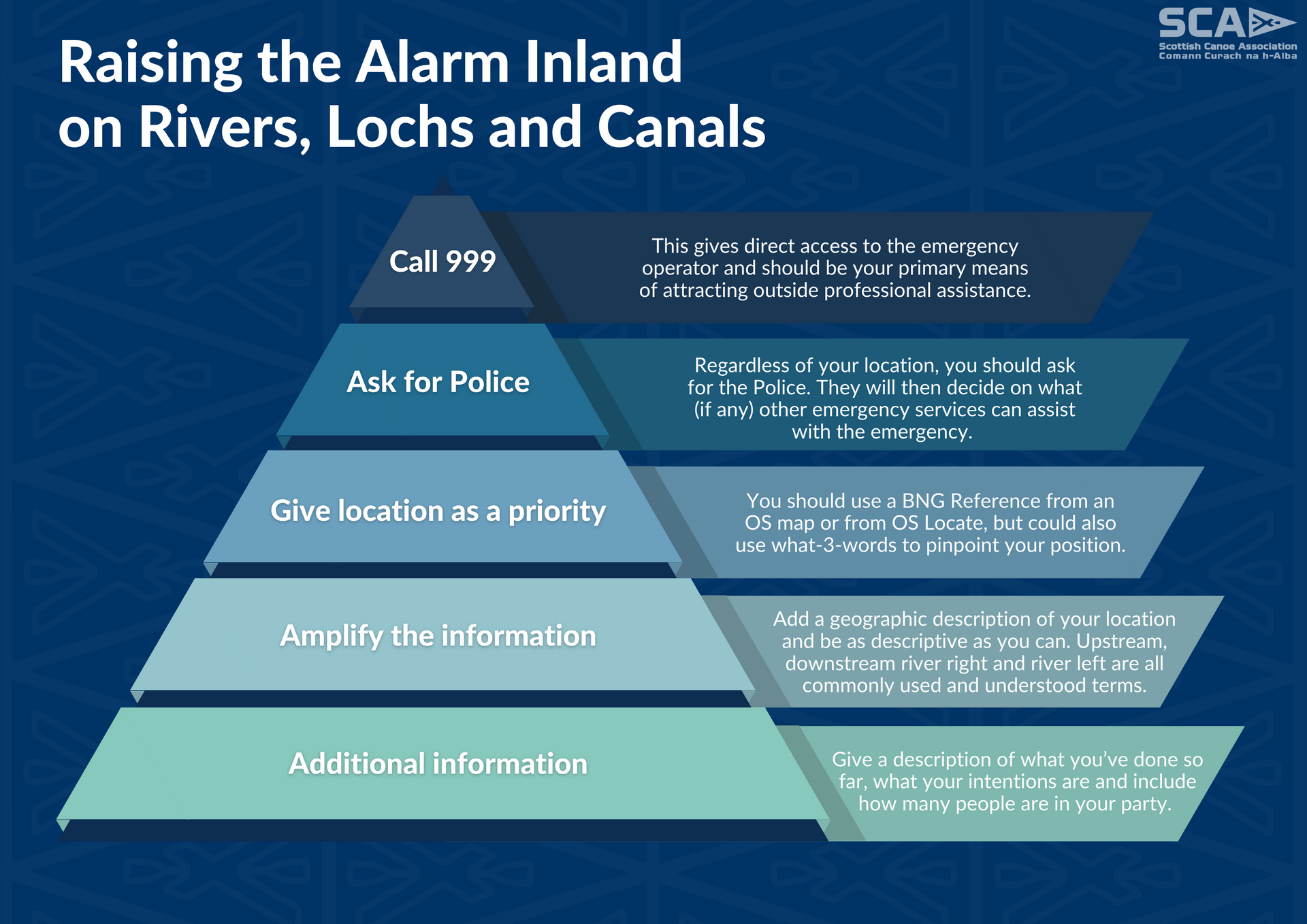
Raising the Alarm Inland on Rivers, Lochs and Canals
Action > Call 999 > This gives direct access to the emergency operator and should be your primary means of attracting outside professional assistance.
Action > Ask for Police > Regardless of your location, you should ask for the Police. They will then decide on what (if any) other emergency services can assist with the emergency.
Action > Give location as a priority > You should use a BNG Reference from an OS map or from OS Locate, but could also use what3words to pinpoint your position.
Action > Amplify this information > Add a geographic description of your location and be as descriptive as you can. Upstream, downstream, river right and river left are all commonly used and understood terms.
Action > Additional info > Give a description of what you’ve done so far, what your intentions are and include how many people are in your party.
Written by SCA Development Manager and experienced paddler Calum McNicol for the April 2022 edition of Scottish Paddler.
HIGHLIGHTED EVENTS
VIEW MORE